Major cold front to arrive on Halloween
MACON, Georgia (41NBC/WMGT) – A powerful cold front will likely bring the first freeze of the season to Middle Georgia later this week.
Tonight


Cloud cover will increase overnight, especially as tomorrow morning draws on. The winds will shift towards the northwest and increase as well. By tomorrow morning speeds will likely range from 5-12 mph with gusts reaching upwards of 20 mph. Temperatures will be slightly cooler than the previous few nights as a result, dropping into the mid 50s for most of the region. A shower or two will also be possible for the northern most parts of the region heading out the door tomorrow morning.
Halloween


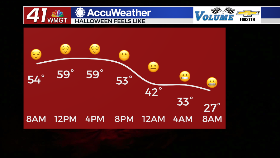
The morning will be mostly cloudy with a few isolated showers over the northern half of the region. These will likely last into the lunchtime hours. The mostly cloudy conditions will limit daytime heating, resulting in high temperatures that largely fall in the 60s. The northwestern counties, however, may only reach the upper 50s while the southeastern counties could push into the lower 70s. A later round of showers will be possible in the southeastern counties as well. These could interfere slightly with anyone who plans to begin Trick-or-Treat ahead of the sunset. These showers will be short lived, however, and skies will clear overnight. An extra layer under the costumes for children is suggested due to the cooler conditions and the increasing winds. Gusts could push upwards of 30 mph heading into tomorrow night.


Strong breezes from the north-northwest will persist under clear skies tomorrow night. Temperatures will plummet into the mid 30s for most of the region rolling into Wednesday morning. The heavy winter gear will likely be needed to begin our Hump Day.
Wednesday and Beyond


With the flip of the calendar comes a change in the weather pattern. Ample sunshine will be accompanied by afternoon highs in the upper 50s and lower 60s through the rest of the week. By Friday these should be climbing back towards the upper 60s. The weekend will continue to see a good bit of sun with highs returning to the 70s, however Saturday could see some clouds fill in during the evening. Also on Sunday don’t forget to set your clocks back as Daylight Savings comes to an end!

Follow Meteorologist Aaron Lowery on Facebook (Aaron Lowery 41NBC) and Twitter (@ALowWX) for weather updates throughout the day. Also, you can watch his forecasts Monday through Friday on 41NBC News at Daybreak (5-7 a.m.) and 41Today (11 a.m).